|
|
|||||||||||||||||
| Point ID: 5138 | Downloads | Plots | Site Data | Code: 03ED002 |
|
|
|||||||||||||||||
| Download | |
|---|---|
| Site Descriptor Information | Site Time Series Data |
| Link to all available data | |
| View: | Time Series | All |
| Units: | m3/s |
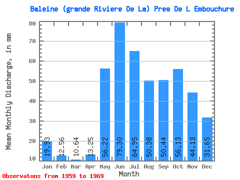
| Statistic | Jan | Feb | Mar | Apr | May | Jun | Jul | Aug | Sep | Oct | Nov | Dec | Annual |
|---|---|---|---|---|---|---|---|---|---|---|---|---|---|
| Mean | 19.93 | 12.67 | 10.64 | 13.25 | 56.21 | 79.30 | 64.94 | 50.37 | 50.44 | 56.13 | 44.13 | 31.65 | 484.99 |
| Standard Deviation | 2.33 | 1.80 | 1.28 | 7.72 | 16.97 | 20.32 | 20.57 | 18.00 | 15.63 | 13.64 | 7.38 | 2.72 | 73.27 |
| Min | 17.23 | 10.28 | 8.99 | 7.98 | 23.49 | 50.40 | 46.12 | 28.58 | 27.06 | 37.69 | 35.34 | 27.03 | 372.89 |
| Max | 23.74 | 15.42 | 13.14 | 31.02 | 78.11 | 111.00 | 115.30 | 75.01 | 82.80 | 72.53 | 53.46 | 35.83 | 605.14 |
| Coefficient of Variation | 0.12 | 0.14 | 0.12 | 0.58 | 0.30 | 0.26 | 0.32 | 0.36 | 0.31 | 0.24 | 0.17 | 0.09 | 0.15 |
 Return to R-Arctic Net Home Page