|
|
|||||||||||||||||
| Point ID: 5137 | Downloads | Plots | Site Data | Other Close Sites | Code: 03ED001 |
|
|
|||||||||||||||||
| Download | |
|---|---|
| Site Descriptor Information | Site Time Series Data |
| Link to all available data | |
| View: | Time Series | All |
| Units: | mm |
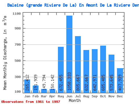
| Statistic | Jan | Feb | Mar | Apr | May | Jun | Jul | Aug | Sep | Oct | Nov | Dec | Annual |
|---|---|---|---|---|---|---|---|---|---|---|---|---|---|
| Mean | 265.41 | 191.94 | 149.79 | 150.14 | 672.46 | 1058.33 | 805.67 | 632.67 | 642.97 | 685.49 | 573.64 | 407.94 | 523.61 |
| Standard Deviation | 36.33 | 28.36 | 23.95 | 54.58 | 187.86 | 269.01 | 209.65 | 185.29 | 170.51 | 145.15 | 109.52 | 71.58 | 63.26 |
| Min | 197.00 | 147.00 | 109.00 | 92.70 | 336.00 | 573.00 | 483.00 | 311.00 | 315.00 | 450.00 | 375.00 | 268.00 | 375.00 |
| Max | 329.00 | 255.00 | 209.00 | 368.00 | 1000.00 | 1570.00 | 1560.00 | 1110.00 | 969.00 | 977.00 | 887.00 | 568.00 | 686.33 |
| Coefficient of Variation | 0.14 | 0.15 | 0.16 | 0.36 | 0.28 | 0.25 | 0.26 | 0.29 | 0.27 | 0.21 | 0.19 | 0.17 | 0.12 |
| Other Close Sites | ||||||
|---|---|---|---|---|---|---|
| PointID | Latitude | Longitude | Drainage Area | Source | Name | |
| 5139 | "BALEINE (GRANDE RIVIERE DE LA) EN AMONT DE LA RIVIERE DENYS" | 55.22 | -852168 | Hydat | ||
 Return to R-Arctic Net Home Page