|
|
|||||||||||||||||
| Point ID: 5137 | Downloads | Plots | Site Data | Other Close Sites | Code: 03ED001 |
|
|
|||||||||||||||||
| Download | |
|---|---|
| Site Descriptor Information | Site Time Series Data |
| Link to all available data | |
| View: | Time Series | All |
| Units: | m3/s |
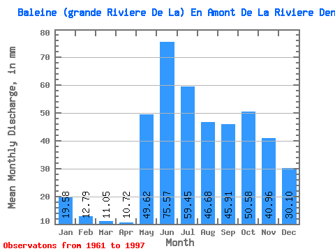
| Statistic | Jan | Feb | Mar | Apr | May | Jun | Jul | Aug | Sep | Oct | Nov | Dec | Annual |
|---|---|---|---|---|---|---|---|---|---|---|---|---|---|
| Mean | 19.58 | 12.90 | 11.05 | 10.72 | 49.61 | 75.57 | 59.44 | 46.67 | 45.91 | 50.57 | 40.96 | 30.09 | 455.24 |
| Standard Deviation | 2.68 | 1.91 | 1.77 | 3.90 | 13.86 | 19.21 | 15.47 | 13.67 | 12.18 | 10.71 | 7.82 | 5.28 | 55.00 |
| Min | 14.53 | 9.88 | 8.04 | 6.62 | 24.79 | 40.91 | 35.63 | 22.94 | 22.49 | 33.20 | 26.78 | 19.77 | 326.03 |
| Max | 24.27 | 17.14 | 15.42 | 26.28 | 73.77 | 112.11 | 115.09 | 81.89 | 69.19 | 72.08 | 63.34 | 41.90 | 596.71 |
| Coefficient of Variation | 0.14 | 0.15 | 0.16 | 0.36 | 0.28 | 0.25 | 0.26 | 0.29 | 0.27 | 0.21 | 0.19 | 0.17 | 0.12 |
| Other Close Sites | ||||||
|---|---|---|---|---|---|---|
| PointID | Latitude | Longitude | Drainage Area | Source | Name | |
| 5139 | "BALEINE (GRANDE RIVIERE DE LA) EN AMONT DE LA RIVIERE DENYS" | 55.22 | -852168 | Hydat | ||
 Return to R-Arctic Net Home Page