|
|
|||||||||||||||||
| Point ID: 5135 | Downloads | Plots | Site Data | Code: 03EA004 |
|
|
|||||||||||||||||
| Download | |
|---|---|
| Site Descriptor Information | Site Time Series Data |
| Link to all available data | |
| View: | Time Series | All |
| Units: | mm |
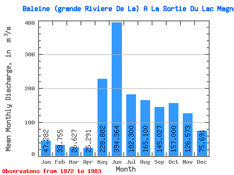
| Statistic | Jan | Feb | Mar | Apr | May | Jun | Jul | Aug | Sep | Oct | Nov | Dec | Annual |
|---|---|---|---|---|---|---|---|---|---|---|---|---|---|
| Mean | 47.28 | 33.76 | 26.63 | 25.29 | 228.88 | 394.36 | 182.30 | 165.10 | 145.03 | 157.00 | 126.57 | 75.69 | 134.97 |
| Standard Deviation | 9.58 | 7.03 | 5.94 | 4.79 | 137.72 | 153.23 | 35.57 | 83.07 | 46.58 | 43.26 | 36.21 | 17.30 | 15.31 |
| Min | 31.10 | 21.20 | 14.90 | 17.40 | 68.40 | 137.00 | 134.00 | 94.00 | 78.30 | 103.00 | 75.60 | 48.00 | 108.43 |
| Max | 64.80 | 43.40 | 35.00 | 30.70 | 474.00 | 645.00 | 242.00 | 325.00 | 235.00 | 219.00 | 201.00 | 109.00 | 160.58 |
| Coefficient of Variation | 0.20 | 0.21 | 0.22 | 0.19 | 0.60 | 0.39 | 0.20 | 0.50 | 0.32 | 0.28 | 0.29 | 0.23 | 0.11 |
 Return to R-Arctic Net Home Page