|
|
|||||||||||||||||
| Point ID: 5135 | Downloads | Plots | Site Data | Code: 03EA004 |
|
|
|||||||||||||||||
| Download | |
|---|---|
| Site Descriptor Information | Site Time Series Data |
| Link to all available data | |
| View: | Time Series | All |
| Units: | m3/s |
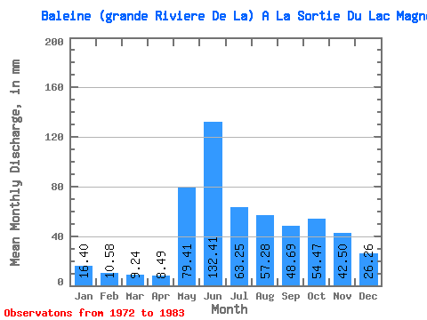
| Statistic | Jan | Feb | Mar | Apr | May | Jun | Jul | Aug | Sep | Oct | Nov | Dec | Annual |
|---|---|---|---|---|---|---|---|---|---|---|---|---|---|
| Mean | 16.40 | 10.67 | 9.24 | 8.49 | 79.40 | 132.41 | 63.24 | 57.27 | 48.69 | 54.46 | 42.50 | 26.26 | 551.76 |
| Standard Deviation | 3.32 | 2.22 | 2.06 | 1.61 | 47.77 | 51.45 | 12.34 | 28.82 | 15.64 | 15.01 | 12.16 | 6.00 | 62.58 |
| Min | 10.79 | 6.70 | 5.17 | 5.84 | 23.73 | 46.00 | 46.48 | 32.61 | 26.29 | 35.73 | 25.38 | 16.65 | 443.28 |
| Max | 22.48 | 13.72 | 12.14 | 10.31 | 164.43 | 216.56 | 83.95 | 112.74 | 78.90 | 75.97 | 67.49 | 37.81 | 656.48 |
| Coefficient of Variation | 0.20 | 0.21 | 0.22 | 0.19 | 0.60 | 0.39 | 0.20 | 0.50 | 0.32 | 0.28 | 0.29 | 0.23 | 0.11 |
 Return to R-Arctic Net Home Page