|
|
|||||||||||||||||
| Point ID: 5118 | Downloads | Plots | Site Data | Code: 03DC003 |
|
|
|||||||||||||||||
| Download | |
|---|---|
| Site Descriptor Information | Site Time Series Data |
| Link to all available data | |
| View: | Time Series | All |
| Units: | mm |
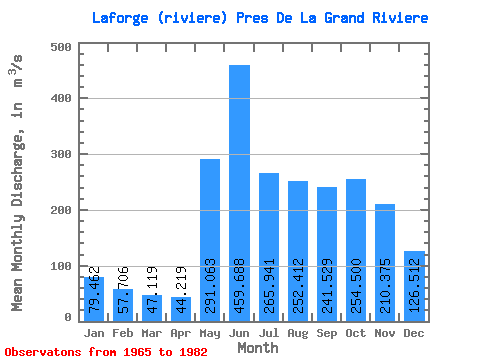
| Statistic | Jan | Feb | Mar | Apr | May | Jun | Jul | Aug | Sep | Oct | Nov | Dec | Annual |
|---|---|---|---|---|---|---|---|---|---|---|---|---|---|
| Mean | 79.46 | 57.71 | 47.12 | 44.22 | 291.06 | 459.69 | 265.94 | 252.41 | 241.53 | 254.50 | 210.38 | 126.51 | 193.38 |
| Standard Deviation | 18.15 | 12.28 | 9.32 | 6.69 | 115.68 | 117.94 | 51.26 | 97.89 | 79.94 | 61.27 | 41.44 | 24.75 | 25.13 |
| Min | 53.60 | 38.60 | 32.40 | 33.50 | 126.00 | 253.00 | 192.00 | 111.00 | 115.00 | 146.00 | 126.00 | 82.70 | 162.02 |
| Max | 131.00 | 93.70 | 66.20 | 54.90 | 559.00 | 644.00 | 405.00 | 460.00 | 389.00 | 356.00 | 286.00 | 167.00 | 245.33 |
| Coefficient of Variation | 0.23 | 0.21 | 0.20 | 0.15 | 0.40 | 0.26 | 0.19 | 0.39 | 0.33 | 0.24 | 0.20 | 0.20 | 0.13 |
 Return to R-Arctic Net Home Page