|
|
|||||||||||||||||
| Point ID: 5118 | Downloads | Plots | Site Data | Code: 03DC003 |
|
|
|||||||||||||||||
| Download | |
|---|---|
| Site Descriptor Information | Site Time Series Data |
| Link to all available data | |
| View: | Time Series | All |
| Units: | m3/s |
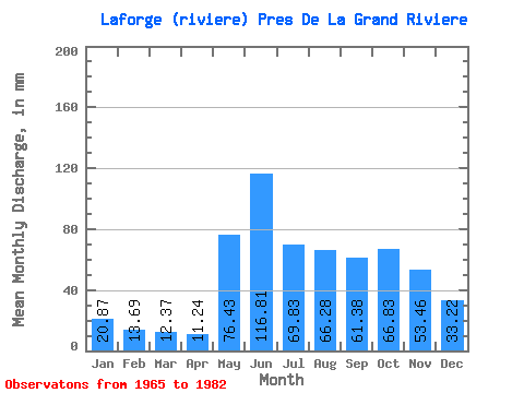
| Statistic | Jan | Feb | Mar | Apr | May | Jun | Jul | Aug | Sep | Oct | Nov | Dec | Annual |
|---|---|---|---|---|---|---|---|---|---|---|---|---|---|
| Mean | 20.86 | 13.80 | 12.37 | 11.24 | 76.42 | 116.81 | 69.82 | 66.27 | 61.38 | 66.82 | 53.46 | 33.22 | 598.34 |
| Standard Deviation | 4.76 | 2.94 | 2.45 | 1.70 | 30.37 | 29.97 | 13.46 | 25.70 | 20.32 | 16.09 | 10.53 | 6.50 | 77.75 |
| Min | 14.07 | 9.23 | 8.51 | 8.51 | 33.08 | 64.29 | 50.41 | 29.14 | 29.22 | 38.33 | 32.02 | 21.71 | 501.30 |
| Max | 34.39 | 22.41 | 17.38 | 13.95 | 146.76 | 163.65 | 106.33 | 120.77 | 98.85 | 93.47 | 72.68 | 43.85 | 759.09 |
| Coefficient of Variation | 0.23 | 0.21 | 0.20 | 0.15 | 0.40 | 0.26 | 0.19 | 0.39 | 0.33 | 0.24 | 0.20 | 0.20 | 0.13 |
 Return to R-Arctic Net Home Page