|
|
|||||||||||||||||
| Point ID: 5098 | Downloads | Plots | Site Data | Code: 03BD002 |
|
|
|||||||||||||||||
| Download | |
|---|---|
| Site Descriptor Information | Site Time Series Data |
| Link to all available data | |
| View: | Time Series | All |
| Units: | mm |
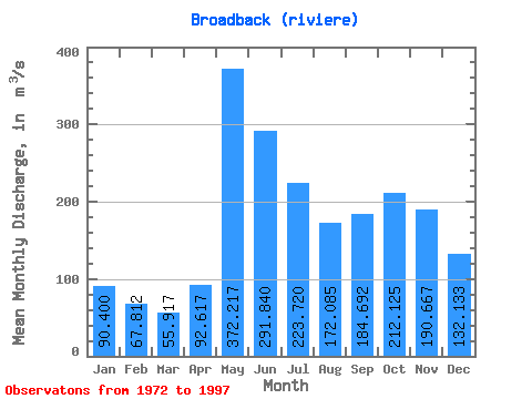
| Statistic | Jan | Feb | Mar | Apr | May | Jun | Jul | Aug | Sep | Oct | Nov | Dec | Annual |
|---|---|---|---|---|---|---|---|---|---|---|---|---|---|
| Mean | 90.40 | 67.81 | 55.92 | 92.62 | 372.22 | 291.84 | 223.72 | 172.09 | 184.69 | 212.12 | 190.67 | 132.13 | 173.46 |
| Standard Deviation | 14.32 | 10.82 | 9.36 | 38.14 | 79.96 | 92.52 | 47.56 | 32.53 | 55.79 | 52.49 | 42.47 | 24.03 | 17.32 |
| Min | 58.60 | 45.50 | 38.50 | 46.00 | 219.00 | 188.00 | 147.00 | 95.20 | 108.00 | 137.00 | 119.00 | 82.20 | 139.88 |
| Max | 115.00 | 91.80 | 74.80 | 169.00 | 534.00 | 615.00 | 335.00 | 251.00 | 341.00 | 363.00 | 290.00 | 174.00 | 214.32 |
| Coefficient of Variation | 0.16 | 0.16 | 0.17 | 0.41 | 0.21 | 0.32 | 0.21 | 0.19 | 0.30 | 0.25 | 0.22 | 0.18 | 0.10 |
 Return to R-Arctic Net Home Page