|
|
|||||||||||||||||
| Point ID: 5098 | Downloads | Plots | Site Data | Code: 03BD002 |
|
|
|||||||||||||||||
| Download | |
|---|---|
| Site Descriptor Information | Site Time Series Data |
| Link to all available data | |
| View: | Time Series | All |
| Units: | m3/s |
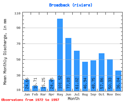
| Statistic | Jan | Feb | Mar | Apr | May | Jun | Jul | Aug | Sep | Oct | Nov | Dec | Annual |
|---|---|---|---|---|---|---|---|---|---|---|---|---|---|
| Mean | 24.65 | 16.85 | 15.25 | 24.45 | 101.51 | 77.03 | 61.01 | 46.93 | 48.75 | 57.85 | 50.33 | 36.03 | 557.47 |
| Standard Deviation | 3.91 | 2.69 | 2.55 | 10.07 | 21.80 | 24.42 | 12.97 | 8.87 | 14.73 | 14.31 | 11.21 | 6.55 | 55.67 |
| Min | 15.98 | 11.30 | 10.50 | 12.14 | 59.72 | 49.62 | 40.09 | 25.96 | 28.51 | 37.36 | 31.41 | 22.42 | 449.54 |
| Max | 31.36 | 22.81 | 20.40 | 44.61 | 145.63 | 162.33 | 91.36 | 68.45 | 90.01 | 98.99 | 76.55 | 47.45 | 688.81 |
| Coefficient of Variation | 0.16 | 0.16 | 0.17 | 0.41 | 0.21 | 0.32 | 0.21 | 0.19 | 0.30 | 0.25 | 0.22 | 0.18 | 0.10 |
 Return to R-Arctic Net Home Page