|
|
|||||||||||||||||
| Point ID: 5096 | Downloads | Plots | Site Data | Code: 03BC002 |
|
|
|||||||||||||||||
| Download | |
|---|---|
| Site Descriptor Information | Site Time Series Data |
| Link to all available data | |
| View: | Time Series | All |
| Units: | mm |
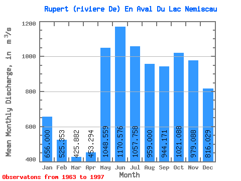
| Statistic | Jan | Feb | Mar | Apr | May | Jun | Jul | Aug | Sep | Oct | Nov | Dec | Annual |
|---|---|---|---|---|---|---|---|---|---|---|---|---|---|
| Mean | 656.00 | 525.35 | 425.88 | 453.29 | 1048.56 | 1170.58 | 1057.76 | 959.00 | 944.17 | 1021.09 | 979.09 | 816.03 | 844.41 |
| Standard Deviation | 124.89 | 91.47 | 61.07 | 105.03 | 204.94 | 211.92 | 172.42 | 160.07 | 208.96 | 204.72 | 187.02 | 154.60 | 92.10 |
| Min | 457.00 | 377.00 | 329.00 | 296.00 | 608.00 | 714.00 | 685.00 | 628.00 | 565.00 | 588.00 | 494.00 | 573.00 | 669.50 |
| Max | 1030.00 | 775.00 | 568.00 | 680.00 | 1640.00 | 1770.00 | 1370.00 | 1310.00 | 1500.00 | 1470.00 | 1490.00 | 1330.00 | 1098.33 |
| Coefficient of Variation | 0.19 | 0.17 | 0.14 | 0.23 | 0.20 | 0.18 | 0.16 | 0.17 | 0.22 | 0.20 | 0.19 | 0.19 | 0.11 |
 Return to R-Arctic Net Home Page