|
|
|||||||||||||||||
| Point ID: 5096 | Downloads | Plots | Site Data | Code: 03BC002 |
|
|
|||||||||||||||||
| Download | |
|---|---|
| Site Descriptor Information | Site Time Series Data |
| Link to all available data | |
| View: | Time Series | All |
| Units: | m3/s |
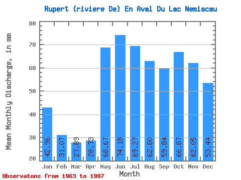
| Statistic | Jan | Feb | Mar | Apr | May | Jun | Jul | Aug | Sep | Oct | Nov | Dec | Annual |
|---|---|---|---|---|---|---|---|---|---|---|---|---|---|
| Mean | 42.95 | 31.34 | 27.89 | 28.73 | 68.66 | 74.18 | 69.26 | 62.79 | 59.84 | 66.86 | 62.05 | 53.43 | 651.58 |
| Standard Deviation | 8.18 | 5.46 | 4.00 | 6.66 | 13.42 | 13.43 | 11.29 | 10.48 | 13.24 | 13.40 | 11.85 | 10.12 | 71.07 |
| Min | 29.92 | 22.49 | 21.54 | 18.76 | 39.81 | 45.25 | 44.85 | 41.12 | 35.81 | 38.50 | 31.31 | 37.52 | 516.61 |
| Max | 67.44 | 46.23 | 37.19 | 43.09 | 107.38 | 112.17 | 89.70 | 85.78 | 95.06 | 96.25 | 94.43 | 87.08 | 847.52 |
| Coefficient of Variation | 0.19 | 0.17 | 0.14 | 0.23 | 0.20 | 0.18 | 0.16 | 0.17 | 0.22 | 0.20 | 0.19 | 0.19 | 0.11 |
 Return to R-Arctic Net Home Page