|
|
|||||||||||||||||
| Point ID: 509 | Downloads | Plots | Site Data | Code: 05EC006 |
|
|
|||||||||||||||||
| Download | |
|---|---|
| Site Descriptor Information | Site Time Series Data |
| Link to all available data | |
| View: | Time Series | All |
| Units: | mm |
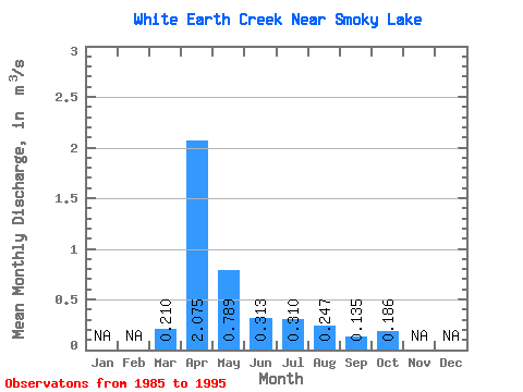
| Statistic | Jan | Feb | Mar | Apr | May | Jun | Jul | Aug | Sep | Oct | Nov | Dec | Annual |
|---|---|---|---|---|---|---|---|---|---|---|---|---|---|
| Mean | 0.21 | 2.08 | 0.79 | 0.31 | 0.31 | 0.25 | 0.14 | 0.19 | |||||
| Standard Deviation | 0.21 | 1.51 | 0.58 | 0.23 | 0.38 | 0.38 | 0.11 | 0.15 | |||||
| Min | 0.02 | 0.29 | 0.10 | 0.07 | 0.01 | 0.00 | 0.00 | 0.00 | |||||
| Max | 0.77 | 4.72 | 1.86 | 0.82 | 1.24 | 1.24 | 0.32 | 0.41 | |||||
| Coefficient of Variation | 1.01 | 0.73 | 0.73 | 0.72 | 1.22 | 1.53 | 0.84 | 0.83 |
 Return to R-Arctic Net Home Page