|
|
|||||||||||||||||
| Point ID: 509 | Downloads | Plots | Site Data | Code: 05EC006 |
|
|
|||||||||||||||||
| Download | |
|---|---|
| Site Descriptor Information | Site Time Series Data |
| Link to all available data | |
| View: | Time Series | All |
| Units: | m3/s |
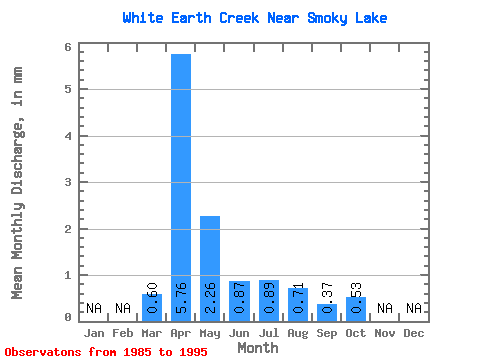
| Statistic | Jan | Feb | Mar | Apr | May | Jun | Jul | Aug | Sep | Oct | Nov | Dec | Annual |
|---|---|---|---|---|---|---|---|---|---|---|---|---|---|
| Mean | 0.56 | 5.38 | 2.11 | 0.81 | 0.83 | 0.66 | 0.35 | 0.50 | |||||
| Standard Deviation | 0.57 | 3.91 | 1.55 | 0.58 | 1.02 | 1.01 | 0.29 | 0.41 | |||||
| Min | 0.06 | 0.75 | 0.25 | 0.18 | 0.03 | 0.01 | 0.00 | 0.00 | |||||
| Max | 2.06 | 12.23 | 4.98 | 2.14 | 3.32 | 3.32 | 0.82 | 1.11 | |||||
| Coefficient of Variation | 1.01 | 0.73 | 0.73 | 0.72 | 1.22 | 1.53 | 0.84 | 0.83 |
 Return to R-Arctic Net Home Page