|
|
|||||||||||||||||
| Point ID: 508 | Downloads | Plots | Site Data | Code: 05EC005 |
|
|
|||||||||||||||||
| Download | |
|---|---|
| Site Descriptor Information | Site Time Series Data |
| Link to all available data | |
| View: | Time Series | All |
| Units: | mm |
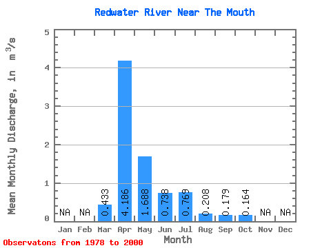
| Statistic | Jan | Feb | Mar | Apr | May | Jun | Jul | Aug | Sep | Oct | Nov | Dec | Annual |
|---|---|---|---|---|---|---|---|---|---|---|---|---|---|
| Mean | 0.43 | 4.19 | 1.69 | 0.74 | 0.77 | 0.21 | 0.18 | 0.16 | |||||
| Standard Deviation | 0.80 | 5.13 | 2.48 | 1.27 | 1.31 | 0.30 | 0.46 | 0.37 | |||||
| Min | 0.02 | 0.05 | 0.05 | 0.01 | 0.00 | 0.00 | 0.00 | 0.00 | |||||
| Max | 2.90 | 20.20 | 7.58 | 5.88 | 4.68 | 1.00 | 2.06 | 1.68 | |||||
| Coefficient of Variation | 1.84 | 1.23 | 1.47 | 1.71 | 1.70 | 1.43 | 2.56 | 2.25 |
 Return to R-Arctic Net Home Page