|
|
|||||||||||||||||
| Point ID: 499 | Downloads | Plots | Site Data | Code: 05EB015 |
|
|
|||||||||||||||||
| Download | |
|---|---|
| Site Descriptor Information | Site Time Series Data |
| Link to all available data | |
| View: | Time Series | All |
| Units: | mm |
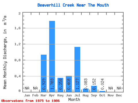
| Statistic | Jan | Feb | Mar | Apr | May | Jun | Jul | Aug | Sep | Oct | Nov | Dec | Annual |
|---|---|---|---|---|---|---|---|---|---|---|---|---|---|
| Mean | 0.94 | 1.78 | 0.36 | 0.41 | 1.13 | 0.08 | 0.15 | 0.02 | |||||
| Standard Deviation | 1.29 | 1.55 | 0.59 | 1.11 | 2.02 | 0.10 | 0.49 | 0.04 | |||||
| Min | 0.00 | 0.26 | 0.01 | 0.00 | 0.00 | 0.00 | 0.00 | 0.00 | |||||
| Max | 3.39 | 5.38 | 1.95 | 3.90 | 6.02 | 0.29 | 1.71 | 0.13 | |||||
| Coefficient of Variation | 1.38 | 0.87 | 1.66 | 2.71 | 1.79 | 1.20 | 3.22 | 1.55 |
 Return to R-Arctic Net Home Page