|
|
|||||||||||||||||
| Point ID: 499 | Downloads | Plots | Site Data | Code: 05EB015 |
|
|
|||||||||||||||||
| Download | |
|---|---|
| Site Descriptor Information | Site Time Series Data |
| Link to all available data | |
| View: | Time Series | All |
| Units: | m3/s |
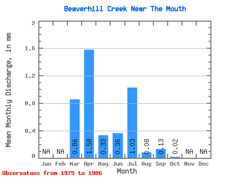
| Statistic | Jan | Feb | Mar | Apr | May | Jun | Jul | Aug | Sep | Oct | Nov | Dec | Annual |
|---|---|---|---|---|---|---|---|---|---|---|---|---|---|
| Mean | 0.86 | 1.58 | 0.33 | 0.36 | 1.03 | 0.08 | 0.14 | 0.02 | |||||
| Standard Deviation | 1.18 | 1.37 | 0.54 | 0.98 | 1.84 | 0.09 | 0.43 | 0.03 | |||||
| Min | 0.00 | 0.23 | 0.01 | 0.00 | 0.00 | 0.00 | 0.00 | 0.00 | |||||
| Max | 3.10 | 4.76 | 1.78 | 3.45 | 5.50 | 0.27 | 1.51 | 0.12 | |||||
| Coefficient of Variation | 1.38 | 0.87 | 1.66 | 2.71 | 1.79 | 1.20 | 3.22 | 1.55 |
 Return to R-Arctic Net Home Page