|
|
|||||||||||||||||
| Point ID: 495 | Downloads | Plots | Site Data | Code: 05EA010 |
|
|
|||||||||||||||||
| Download | |
|---|---|
| Site Descriptor Information | Site Time Series Data |
| Link to all available data | |
| View: | Time Series | All |
| Units: | mm |
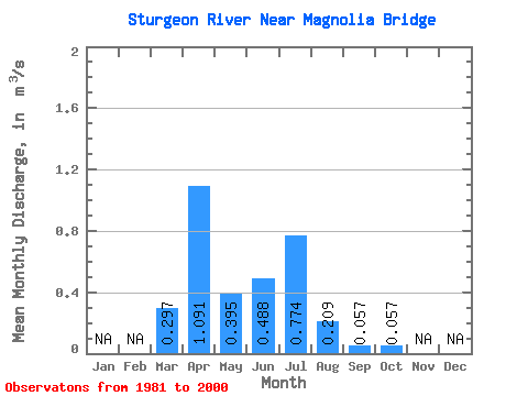
| Statistic | Jan | Feb | Mar | Apr | May | Jun | Jul | Aug | Sep | Oct | Nov | Dec | Annual |
|---|---|---|---|---|---|---|---|---|---|---|---|---|---|
| Mean | 0.30 | 1.09 | 0.40 | 0.49 | 0.77 | 0.21 | 0.06 | 0.06 | |||||
| Standard Deviation | 0.27 | 1.07 | 0.44 | 0.79 | 0.96 | 0.38 | 0.10 | 0.08 | |||||
| Min | 0.00 | 0.03 | 0.02 | 0.05 | 0.00 | 0.00 | 0.00 | 0.00 | |||||
| Max | 0.89 | 3.21 | 1.64 | 3.10 | 2.72 | 1.45 | 0.44 | 0.35 | |||||
| Coefficient of Variation | 0.91 | 0.98 | 1.11 | 1.62 | 1.25 | 1.80 | 1.69 | 1.35 |
 Return to R-Arctic Net Home Page