|
|
|||||||||||||||||
| Point ID: 495 | Downloads | Plots | Site Data | Code: 05EA010 |
|
|
|||||||||||||||||
| Download | |
|---|---|
| Site Descriptor Information | Site Time Series Data |
| Link to all available data | |
| View: | Time Series | All |
| Units: | m3/s |
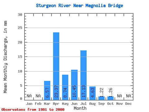
| Statistic | Jan | Feb | Mar | Apr | May | Jun | Jul | Aug | Sep | Oct | Nov | Dec | Annual |
|---|---|---|---|---|---|---|---|---|---|---|---|---|---|
| Mean | 6.57 | 23.38 | 8.74 | 10.45 | 17.12 | 4.63 | 1.23 | 1.26 | |||||
| Standard Deviation | 5.96 | 22.85 | 9.75 | 16.89 | 21.35 | 8.31 | 2.08 | 1.70 | |||||
| Min | 0.00 | 0.60 | 0.42 | 0.98 | 0.00 | 0.00 | 0.00 | 0.00 | |||||
| Max | 19.59 | 68.76 | 36.30 | 66.41 | 60.20 | 32.09 | 9.34 | 7.75 | |||||
| Coefficient of Variation | 0.91 | 0.98 | 1.11 | 1.62 | 1.25 | 1.80 | 1.69 | 1.35 |
 Return to R-Arctic Net Home Page