|
|
|||||||||||||||||
| Point ID: 491 | Downloads | Plots | Site Data | Code: 05EA003 |
|
|
|||||||||||||||||
| Download | |
|---|---|
| Site Descriptor Information | Site Time Series Data |
| Link to all available data | |
| View: | Time Series | All |
| Units: | mm |
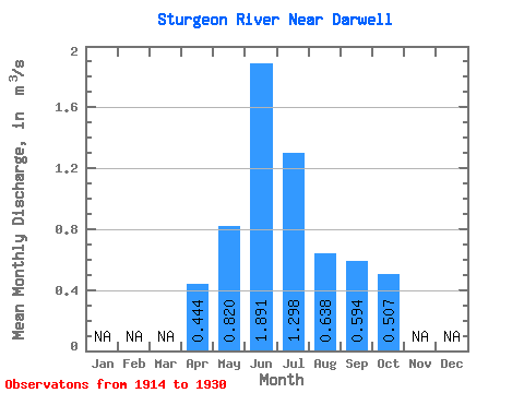
| Statistic | Jan | Feb | Mar | Apr | May | Jun | Jul | Aug | Sep | Oct | Nov | Dec | Annual |
|---|---|---|---|---|---|---|---|---|---|---|---|---|---|
| Mean | 0.44 | 0.82 | 1.89 | 1.30 | 0.64 | 0.59 | 0.51 | ||||||
| Standard Deviation | 0.31 | 0.95 | 1.90 | 1.32 | 0.74 | 0.71 | 0.59 | ||||||
| Min | 0.15 | 0.21 | 0.15 | 0.03 | 0.00 | 0.00 | 0.00 | ||||||
| Max | 0.77 | 2.49 | 4.39 | 2.93 | 1.44 | 1.47 | 1.21 | ||||||
| Coefficient of Variation | 0.70 | 1.16 | 1.00 | 1.01 | 1.15 | 1.20 | 1.17 |
 Return to R-Arctic Net Home Page