|
|
| Point ID: 491 | Downloads | Plots | Site Data | Code: 05EA003 |
|
| Download | |
|---|---|
| Site Descriptor Information | Site Time Series Data |
| Link to all available data | |
|
|
|
| View: | Statistics | All |
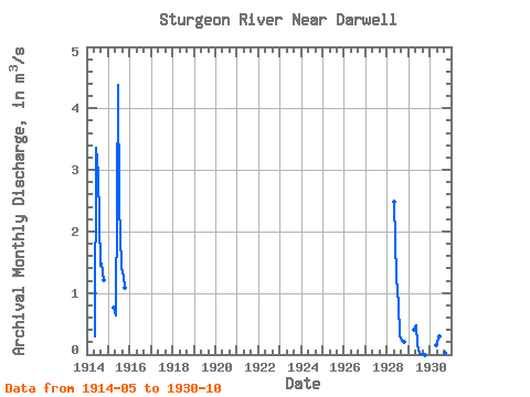
| Units: | mm |
| Year | Jan | Feb | Mar | Apr | May | Jun | Jul | Aug | Sep | Oct | Nov | Dec | Annual | 1914 | 0.30 | 3.36 | 2.93 | 1.44 | 1.47 | 1.21 | 1915 | 0.77 | 0.63 | 4.39 | 2.45 | 1.43 | 1.26 | 1.09 | 1928 | 2.49 | 1.25 | 0.84 | 0.30 | 0.22 | 0.20 | 1929 | 0.41 | 0.47 | 0.15 | 0.03 | 0.00 | 0.00 | 0.00 | 1930 | 0.15 | 0.21 | 0.30 | 0.24 | 0.02 | 0.02 | 0.03 |
|---|
 Return to R-Arctic Net Home Page