|
|
|||||||||||||||||
| Point ID: 478 | Downloads | Plots | Site Data | Code: 05DE003 |
|
|
|||||||||||||||||
| Download | |
|---|---|
| Site Descriptor Information | Site Time Series Data |
| Link to all available data | |
| View: | Time Series | All |
| Units: | mm |
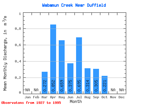
| Statistic | Jan | Feb | Mar | Apr | May | Jun | Jul | Aug | Sep | Oct | Nov | Dec | Annual |
|---|---|---|---|---|---|---|---|---|---|---|---|---|---|
| Mean | 0.27 | 0.85 | 0.66 | 0.38 | 0.69 | 0.31 | 0.30 | 0.22 | |||||
| Standard Deviation | 0.27 | 1.04 | 0.95 | 0.41 | 0.97 | 0.48 | 0.51 | 0.36 | |||||
| Min | 0.00 | 0.00 | 0.04 | 0.00 | 0.00 | 0.00 | 0.00 | 0.00 | |||||
| Max | 0.98 | 5.53 | 4.55 | 1.86 | 4.03 | 2.30 | 2.07 | 1.48 | |||||
| Coefficient of Variation | 0.98 | 1.22 | 1.45 | 1.10 | 1.40 | 1.52 | 1.69 | 1.62 |
 Return to R-Arctic Net Home Page