|
|
|||||||||||||||||
| Point ID: 478 | Downloads | Plots | Site Data | Code: 05DE003 |
|
|
|||||||||||||||||
| Download | |
|---|---|
| Site Descriptor Information | Site Time Series Data |
| Link to all available data | |
| View: | Time Series | All |
| Units: | m3/s |
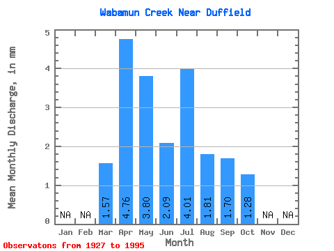
| Statistic | Jan | Feb | Mar | Apr | May | Jun | Jul | Aug | Sep | Oct | Nov | Dec | Annual |
|---|---|---|---|---|---|---|---|---|---|---|---|---|---|
| Mean | 1.42 | 4.30 | 3.44 | 1.89 | 3.63 | 1.64 | 1.54 | 1.16 | |||||
| Standard Deviation | 1.39 | 5.24 | 4.98 | 2.09 | 5.08 | 2.49 | 2.60 | 1.87 | |||||
| Min | 0.00 | 0.00 | 0.23 | 0.00 | 0.00 | 0.00 | 0.00 | 0.00 | |||||
| Max | 5.09 | 27.94 | 23.75 | 9.40 | 21.04 | 12.01 | 10.46 | 7.73 | |||||
| Coefficient of Variation | 0.98 | 1.22 | 1.45 | 1.10 | 1.40 | 1.52 | 1.69 | 1.62 |
 Return to R-Arctic Net Home Page