|
|
|||||||||||||||||
| Point ID: 476 | Downloads | Plots | Site Data | Code: 05DD009 |
|
|
|||||||||||||||||
| Download | |
|---|---|
| Site Descriptor Information | Site Time Series Data |
| Link to all available data | |
| View: | Time Series | All |
| Units: | mm |
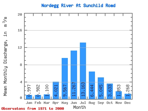
| Statistic | Jan | Feb | Mar | Apr | May | Jun | Jul | Aug | Sep | Oct | Nov | Dec | Annual |
|---|---|---|---|---|---|---|---|---|---|---|---|---|---|
| Mean | 1.00 | 0.98 | 1.10 | 4.02 | 9.57 | 11.27 | 13.16 | 6.44 | 5.04 | 3.63 | 1.85 | 1.27 | 4.95 |
| Standard Deviation | 0.37 | 0.34 | 0.47 | 2.08 | 5.62 | 8.63 | 12.42 | 4.80 | 3.23 | 2.55 | 0.93 | 0.48 | 2.08 |
| Min | 0.38 | 0.33 | 0.33 | 1.39 | 1.90 | 3.16 | 2.17 | 1.77 | 1.17 | 0.99 | 0.68 | 0.65 | 1.74 |
| Max | 1.87 | 1.72 | 2.68 | 10.00 | 24.50 | 36.40 | 50.70 | 26.20 | 13.30 | 14.80 | 5.03 | 2.46 | 10.27 |
| Coefficient of Variation | 0.37 | 0.34 | 0.42 | 0.52 | 0.59 | 0.77 | 0.94 | 0.74 | 0.64 | 0.70 | 0.50 | 0.38 | 0.42 |
 Return to R-Arctic Net Home Page