|
|
|||||||||||||||||
| Point ID: 476 | Downloads | Plots | Site Data | Code: 05DD009 |
|
|
|||||||||||||||||
| Download | |
|---|---|
| Site Descriptor Information | Site Time Series Data |
| Link to all available data | |
| View: | Time Series | All |
| Units: | m3/s |
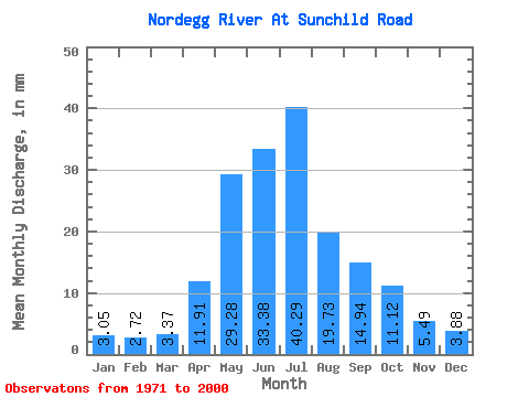
| Statistic | Jan | Feb | Mar | Apr | May | Jun | Jul | Aug | Sep | Oct | Nov | Dec | Annual |
|---|---|---|---|---|---|---|---|---|---|---|---|---|---|
| Mean | 3.05 | 2.74 | 3.37 | 11.91 | 29.28 | 33.38 | 40.29 | 19.72 | 14.94 | 11.12 | 5.49 | 3.88 | 178.65 |
| Standard Deviation | 1.14 | 0.94 | 1.43 | 6.16 | 17.20 | 25.57 | 38.00 | 14.69 | 9.55 | 7.80 | 2.76 | 1.46 | 75.10 |
| Min | 1.15 | 0.92 | 1.01 | 4.12 | 5.81 | 9.36 | 6.64 | 5.42 | 3.47 | 3.04 | 2.02 | 1.98 | 62.87 |
| Max | 5.72 | 4.80 | 8.20 | 29.62 | 74.98 | 107.83 | 155.17 | 80.19 | 39.40 | 45.30 | 14.90 | 7.53 | 370.48 |
| Coefficient of Variation | 0.37 | 0.34 | 0.42 | 0.52 | 0.59 | 0.77 | 0.94 | 0.74 | 0.64 | 0.70 | 0.50 | 0.38 | 0.42 |
 Return to R-Arctic Net Home Page