|
|
|||||||||||||||||
| Point ID: 474 | Downloads | Plots | Site Data | Code: 05DD007 |
|
|
|||||||||||||||||
| Download | |
|---|---|
| Site Descriptor Information | Site Time Series Data |
| Link to all available data | |
| View: | Time Series | All |
| Units: | mm |
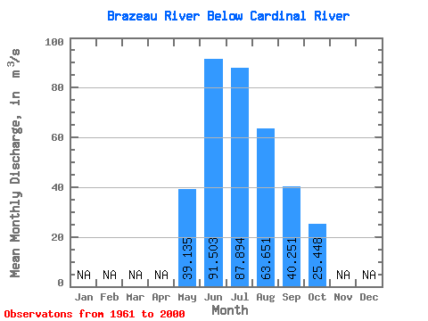
| Statistic | Jan | Feb | Mar | Apr | May | Jun | Jul | Aug | Sep | Oct | Nov | Dec | Annual |
|---|---|---|---|---|---|---|---|---|---|---|---|---|---|
| Mean | 39.13 | 91.50 | 87.89 | 63.65 | 40.25 | 25.45 | |||||||
| Standard Deviation | 12.75 | 31.12 | 26.85 | 17.30 | 10.03 | 5.76 | |||||||
| Min | 17.50 | 48.40 | 45.90 | 39.60 | 23.50 | 14.60 | |||||||
| Max | 68.80 | 164.00 | 155.00 | 103.00 | 59.10 | 40.20 | |||||||
| Coefficient of Variation | 0.33 | 0.34 | 0.30 | 0.27 | 0.25 | 0.23 |
 Return to R-Arctic Net Home Page