|
|
|||||||||||||||||
| Point ID: 474 | Downloads | Plots | Site Data | Code: 05DD007 |
|
|
|||||||||||||||||
| Download | |
|---|---|
| Site Descriptor Information | Site Time Series Data |
| Link to all available data | |
| View: | Time Series | All |
| Units: | m3/s |
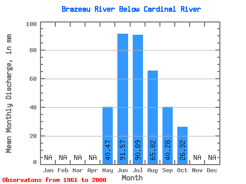
| Statistic | Jan | Feb | Mar | Apr | May | Jun | Jul | Aug | Sep | Oct | Nov | Dec | Annual |
|---|---|---|---|---|---|---|---|---|---|---|---|---|---|
| Mean | 40.47 | 91.57 | 90.88 | 65.81 | 40.28 | 26.31 | |||||||
| Standard Deviation | 13.19 | 31.14 | 27.76 | 17.89 | 10.04 | 5.95 | |||||||
| Min | 18.09 | 48.44 | 47.46 | 40.95 | 23.52 | 15.10 | |||||||
| Max | 71.14 | 164.13 | 160.27 | 106.50 | 59.15 | 41.57 | |||||||
| Coefficient of Variation | 0.33 | 0.34 | 0.30 | 0.27 | 0.25 | 0.23 |
 Return to R-Arctic Net Home Page