|
|
|||||||||||||||||
| Point ID: 47 | Downloads | Plots | Site Data | Code: 05AB029 |
|
|
|||||||||||||||||
| Download | |
|---|---|
| Site Descriptor Information | Site Time Series Data |
| Link to all available data | |
| View: | Time Series | All |
| Units: | mm |
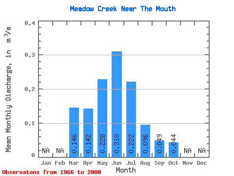
| Statistic | Jan | Feb | Mar | Apr | May | Jun | Jul | Aug | Sep | Oct | Nov | Dec | Annual |
|---|---|---|---|---|---|---|---|---|---|---|---|---|---|
| Mean | 0.15 | 0.14 | 0.23 | 0.31 | 0.22 | 0.10 | 0.05 | 0.04 | |||||
| Standard Deviation | 0.21 | 0.15 | 0.37 | 0.46 | 0.51 | 0.24 | 0.12 | 0.08 | |||||
| Min | 0.00 | 0.00 | 0.00 | 0.00 | 0.00 | 0.00 | 0.00 | 0.00 | |||||
| Max | 0.92 | 0.80 | 2.10 | 1.70 | 2.50 | 1.35 | 0.68 | 0.43 | |||||
| Coefficient of Variation | 1.44 | 1.08 | 1.63 | 1.47 | 2.29 | 2.50 | 2.42 | 1.79 |
 Return to R-Arctic Net Home Page