|
|
|||||||||||||||||
| Point ID: 47 | Downloads | Plots | Site Data | Code: 05AB029 |
|
|
|||||||||||||||||
| Download | |
|---|---|
| Site Descriptor Information | Site Time Series Data |
| Link to all available data | |
| View: | Time Series | All |
| Units: | m3/s |
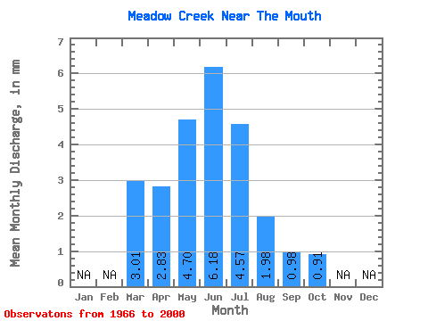
| Statistic | Jan | Feb | Mar | Apr | May | Jun | Jul | Aug | Sep | Oct | Nov | Dec | Annual |
|---|---|---|---|---|---|---|---|---|---|---|---|---|---|
| Mean | 3.01 | 2.84 | 4.69 | 6.18 | 4.58 | 1.98 | 0.98 | 0.90 | |||||
| Standard Deviation | 4.32 | 3.06 | 7.63 | 9.08 | 10.50 | 4.97 | 2.36 | 1.61 | |||||
| Min | 0.00 | 0.00 | 0.00 | 0.00 | 0.00 | 0.00 | 0.00 | 0.00 | |||||
| Max | 18.89 | 15.91 | 43.26 | 33.90 | 51.50 | 27.81 | 13.50 | 8.88 | |||||
| Coefficient of Variation | 1.44 | 1.08 | 1.63 | 1.47 | 2.29 | 2.50 | 2.42 | 1.79 |
 Return to R-Arctic Net Home Page