|
|
|||||||||||||||||
| Point ID: 467 | Downloads | Plots | Site Data | Code: 05DC011 |
|
|
|||||||||||||||||
| Download | |
|---|---|
| Site Descriptor Information | Site Time Series Data |
| Link to all available data | |
| View: | Time Series | All |
| Units: | mm |
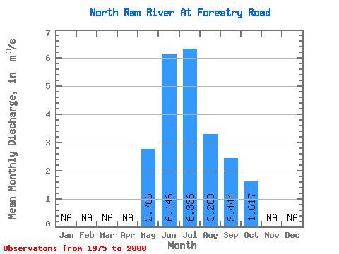
| Statistic | Jan | Feb | Mar | Apr | May | Jun | Jul | Aug | Sep | Oct | Nov | Dec | Annual |
|---|---|---|---|---|---|---|---|---|---|---|---|---|---|
| Mean | 2.77 | 6.15 | 6.34 | 3.29 | 2.44 | 1.62 | |||||||
| Standard Deviation | 1.87 | 4.39 | 4.61 | 1.64 | 1.52 | 0.91 | |||||||
| Min | 0.58 | 1.15 | 1.61 | 1.03 | 0.72 | 0.49 | |||||||
| Max | 7.91 | 18.70 | 18.70 | 6.58 | 6.82 | 5.05 | |||||||
| Coefficient of Variation | 0.68 | 0.71 | 0.73 | 0.50 | 0.62 | 0.56 |
 Return to R-Arctic Net Home Page