|
|
|||||||||||||||||
| Point ID: 467 | Downloads | Plots | Site Data | Code: 05DC011 |
|
|
|||||||||||||||||
| Download | |
|---|---|
| Site Descriptor Information | Site Time Series Data |
| Link to all available data | |
| View: | Time Series | All |
| Units: | m3/s |
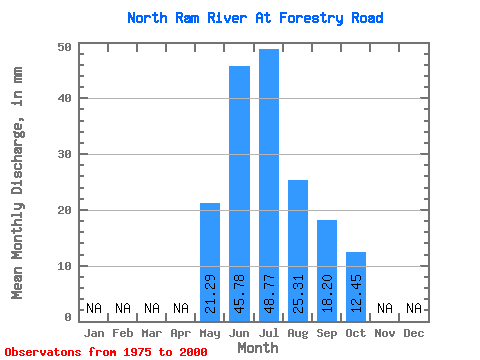
| Statistic | Jan | Feb | Mar | Apr | May | Jun | Jul | Aug | Sep | Oct | Nov | Dec | Annual |
|---|---|---|---|---|---|---|---|---|---|---|---|---|---|
| Mean | 21.29 | 45.78 | 48.76 | 25.31 | 18.20 | 12.44 | |||||||
| Standard Deviation | 14.42 | 32.72 | 35.47 | 12.59 | 11.34 | 6.97 | |||||||
| Min | 4.46 | 8.57 | 12.39 | 7.93 | 5.39 | 3.75 | |||||||
| Max | 60.87 | 139.28 | 143.90 | 50.64 | 50.80 | 38.86 | |||||||
| Coefficient of Variation | 0.68 | 0.71 | 0.73 | 0.50 | 0.62 | 0.56 |
 Return to R-Arctic Net Home Page