|
|
|||||||||||||||||
| Point ID: 446 | Downloads | Plots | Site Data | Code: 05DA006 |
|
|
|||||||||||||||||
| Download | |
|---|---|
| Site Descriptor Information | Site Time Series Data |
| Link to all available data | |
| View: | Time Series | All |
| Units: | mm |
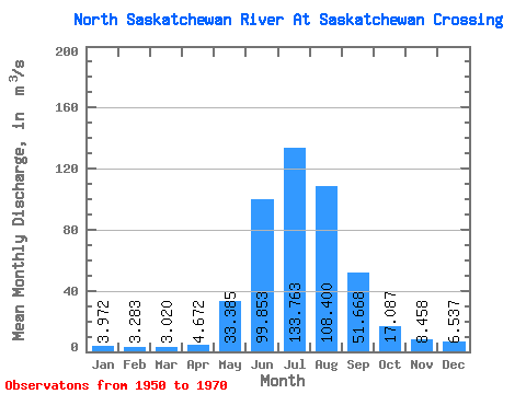
| Statistic | Jan | Feb | Mar | Apr | May | Jun | Jul | Aug | Sep | Oct | Nov | Dec | Annual |
|---|---|---|---|---|---|---|---|---|---|---|---|---|---|
| Mean | 3.97 | 3.28 | 3.02 | 4.67 | 33.38 | 99.85 | 133.76 | 108.40 | 51.67 | 17.09 | 8.46 | 6.54 | 41.97 |
| Standard Deviation | 1.71 | 0.71 | 1.17 | 1.81 | 15.06 | 23.38 | 18.79 | 20.09 | 16.20 | 4.07 | 0.56 | 1.30 | 5.48 |
| Min | 2.60 | 2.66 | 1.85 | 3.07 | 16.90 | 71.70 | 92.50 | 67.70 | 24.30 | 9.58 | 7.89 | 5.68 | 38.68 |
| Max | 6.35 | 4.04 | 4.63 | 6.47 | 62.00 | 152.00 | 160.00 | 143.00 | 89.00 | 25.40 | 9.22 | 8.44 | 48.30 |
| Coefficient of Variation | 0.43 | 0.21 | 0.39 | 0.39 | 0.45 | 0.23 | 0.14 | 0.18 | 0.31 | 0.24 | 0.07 | 0.20 | 0.13 |
 Return to R-Arctic Net Home Page