|
|
|||||||||||||||||
| Point ID: 446 | Downloads | Plots | Site Data | Code: 05DA006 |
|
|
|||||||||||||||||
| Download | |
|---|---|
| Site Descriptor Information | Site Time Series Data |
| Link to all available data | |
| View: | Time Series | All |
| Units: | m3/s |
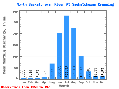
| Statistic | Jan | Feb | Mar | Apr | May | Jun | Jul | Aug | Sep | Oct | Nov | Dec | Annual |
|---|---|---|---|---|---|---|---|---|---|---|---|---|---|
| Mean | 8.25 | 6.21 | 6.27 | 9.39 | 69.31 | 200.63 | 277.69 | 225.03 | 103.82 | 35.47 | 16.99 | 13.57 | 1026.86 |
| Standard Deviation | 3.55 | 1.34 | 2.42 | 3.65 | 31.25 | 46.98 | 39.01 | 41.71 | 32.54 | 8.44 | 1.12 | 2.69 | 134.06 |
| Min | 5.40 | 5.03 | 3.84 | 6.17 | 35.08 | 144.07 | 192.03 | 140.54 | 48.83 | 19.89 | 15.85 | 11.79 | 946.23 |
| Max | 13.18 | 7.64 | 9.61 | 13.00 | 128.71 | 305.41 | 332.15 | 296.86 | 178.83 | 52.73 | 18.53 | 17.52 | 1181.60 |
| Coefficient of Variation | 0.43 | 0.21 | 0.39 | 0.39 | 0.45 | 0.23 | 0.14 | 0.18 | 0.31 | 0.24 | 0.07 | 0.20 | 0.13 |
 Return to R-Arctic Net Home Page