|
|
|||||||||||||||||
| Point ID: 4428 | Downloads | Plots | Site Data | Code: 05QA002 |
|
|
|||||||||||||||||
| Download | |
|---|---|
| Site Descriptor Information | Site Time Series Data |
| Link to all available data | |
| View: | Time Series | All |
| Units: | mm |
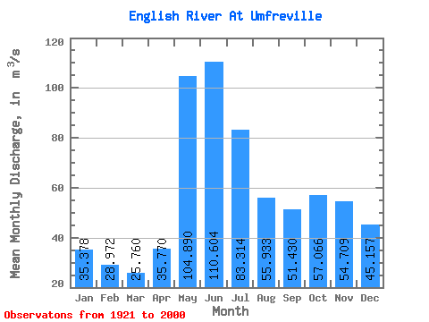
| Statistic | Jan | Feb | Mar | Apr | May | Jun | Jul | Aug | Sep | Oct | Nov | Dec | Annual |
|---|---|---|---|---|---|---|---|---|---|---|---|---|---|
| Mean | 35.38 | 28.97 | 25.76 | 35.77 | 104.89 | 110.60 | 83.31 | 55.93 | 51.43 | 57.07 | 54.71 | 45.16 | 57.44 |
| Standard Deviation | 13.50 | 9.08 | 7.21 | 13.10 | 47.33 | 54.43 | 40.77 | 25.58 | 36.90 | 51.24 | 38.30 | 22.32 | 19.68 |
| Min | 8.84 | 9.79 | 9.81 | 12.50 | 24.20 | 29.10 | 23.00 | 15.70 | 7.78 | 3.15 | 3.21 | 6.70 | 16.58 |
| Max | 88.00 | 53.50 | 41.80 | 82.00 | 235.00 | 274.00 | 211.00 | 121.00 | 197.00 | 372.00 | 255.00 | 146.00 | 100.38 |
| Coefficient of Variation | 0.38 | 0.31 | 0.28 | 0.37 | 0.45 | 0.49 | 0.49 | 0.46 | 0.72 | 0.90 | 0.70 | 0.49 | 0.34 |
 Return to R-Arctic Net Home Page