|
|
|||||||||||||||||
| Point ID: 4428 | Downloads | Plots | Site Data | Code: 05QA002 |
|
|
|||||||||||||||||
| Download | |
|---|---|
| Site Descriptor Information | Site Time Series Data |
| Link to all available data | |
| View: | Time Series | All |
| Units: | m3/s |
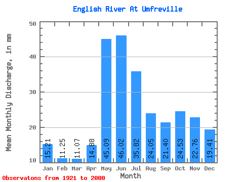
| Statistic | Jan | Feb | Mar | Apr | May | Jun | Jul | Aug | Sep | Oct | Nov | Dec | Annual |
|---|---|---|---|---|---|---|---|---|---|---|---|---|---|
| Mean | 15.21 | 11.35 | 11.07 | 14.88 | 45.09 | 46.02 | 35.81 | 24.04 | 21.40 | 24.53 | 22.76 | 19.41 | 290.95 |
| Standard Deviation | 5.80 | 3.56 | 3.10 | 5.45 | 20.35 | 22.64 | 17.53 | 11.00 | 15.35 | 22.03 | 15.94 | 9.59 | 99.69 |
| Min | 3.80 | 3.83 | 4.22 | 5.20 | 10.40 | 12.11 | 9.89 | 6.75 | 3.24 | 1.35 | 1.34 | 2.88 | 83.98 |
| Max | 37.83 | 20.95 | 17.97 | 34.12 | 101.02 | 114.00 | 90.70 | 52.01 | 81.96 | 159.91 | 106.09 | 62.76 | 508.48 |
| Coefficient of Variation | 0.38 | 0.31 | 0.28 | 0.37 | 0.45 | 0.49 | 0.49 | 0.46 | 0.72 | 0.90 | 0.70 | 0.49 | 0.34 |
 Return to R-Arctic Net Home Page