|
|
|||||||||||||||||
| Point ID: 4400 | Downloads | Plots | Site Data | Code: 05PC011 |
|
|
|||||||||||||||||
| Download | |
|---|---|
| Site Descriptor Information | Site Time Series Data |
| Link to all available data | |
| View: | Time Series | All |
| Units: | mm |
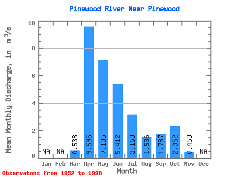
| Statistic | Jan | Feb | Mar | Apr | May | Jun | Jul | Aug | Sep | Oct | Nov | Dec | Annual |
|---|---|---|---|---|---|---|---|---|---|---|---|---|---|
| Mean | 0.54 | 9.60 | 7.13 | 5.41 | 3.16 | 1.54 | 1.79 | 2.35 | 0.45 | ||||
| Standard Deviation | 0.84 | 6.92 | 5.68 | 4.54 | 3.38 | 2.25 | 2.82 | 2.94 | 0.12 | ||||
| Min | 0.00 | 0.84 | 0.27 | 0.09 | 0.04 | 0.00 | 0.00 | 0.01 | 0.36 | ||||
| Max | 4.56 | 27.40 | 26.00 | 19.30 | 13.40 | 9.09 | 12.40 | 12.80 | 0.54 | ||||
| Coefficient of Variation | 1.57 | 0.72 | 0.80 | 0.84 | 1.07 | 1.47 | 1.58 | 1.25 | 0.28 |
 Return to R-Arctic Net Home Page