|
|
|||||||||||||||||
| Point ID: 4400 | Downloads | Plots | Site Data | Code: 05PC011 |
|
|
|||||||||||||||||
| Download | |
|---|---|
| Site Descriptor Information | Site Time Series Data |
| Link to all available data | |
| View: | Time Series | All |
| Units: | m3/s |
| Statistic | Jan | Feb | Mar | Apr | May | Jun | Jul | Aug | Sep | Oct | Nov | Dec | Annual |
|---|---|---|---|---|---|---|---|---|---|---|---|---|---|
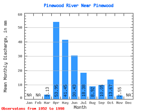
| Mean | 3.12 | 53.95 | 41.45 | 30.43 | 18.37 | 8.92 | 10.05 | 13.66 | 2.54 | ||||
| Standard Deviation | 4.90 | 38.90 | 32.98 | 25.53 | 19.66 | 13.09 | 15.88 | 17.06 | 0.70 | ||||
| Min | 0.00 | 4.72 | 1.58 | 0.48 | 0.21 | 0.02 | 0.00 | 0.05 | 2.05 | ||||
| Max | 26.49 | 154.06 | 151.04 | 108.52 | 77.84 | 52.80 | 69.72 | 74.36 | 3.04 | ||||
| Coefficient of Variation | 1.57 | 0.72 | 0.80 | 0.84 | 1.07 | 1.47 | 1.58 | 1.25 | 0.28 |
 Return to R-Arctic Net Home Page