|
|
|||||||||||||||||
| Point ID: 4399 | Downloads | Plots | Site Data | Code: 05PC010 |
|
|
|||||||||||||||||
| Download | |
|---|---|
| Site Descriptor Information | Site Time Series Data |
| Link to all available data | |
| View: | Time Series | All |
| Units: | mm |
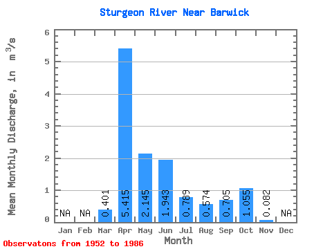
| Statistic | Jan | Feb | Mar | Apr | May | Jun | Jul | Aug | Sep | Oct | Nov | Dec | Annual |
|---|---|---|---|---|---|---|---|---|---|---|---|---|---|
| Mean | 0.40 | 5.42 | 2.15 | 1.94 | 0.79 | 0.57 | 0.70 | 1.05 | 0.08 | ||||
| Standard Deviation | 0.62 | 3.09 | 1.75 | 2.06 | 1.00 | 1.02 | 1.20 | 1.50 | |||||
| Min | 0.00 | 0.39 | 0.17 | 0.00 | 0.00 | 0.00 | 0.00 | 0.00 | 0.08 | ||||
| Max | 2.44 | 12.80 | 7.88 | 8.36 | 3.36 | 3.68 | 4.86 | 5.85 | 0.08 | ||||
| Coefficient of Variation | 1.54 | 0.57 | 0.81 | 1.06 | 1.27 | 1.78 | 1.70 | 1.42 |
 Return to R-Arctic Net Home Page