|
|
|||||||||||||||||
| Point ID: 4399 | Downloads | Plots | Site Data | Code: 05PC010 |
|
|
|||||||||||||||||
| Download | |
|---|---|
| Site Descriptor Information | Site Time Series Data |
| Link to all available data | |
| View: | Time Series | All |
| Units: | m3/s |
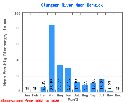
| Statistic | Jan | Feb | Mar | Apr | May | Jun | Jul | Aug | Sep | Oct | Nov | Dec | Annual |
|---|---|---|---|---|---|---|---|---|---|---|---|---|---|
| Mean | 6.39 | 83.55 | 34.20 | 29.98 | 12.58 | 9.16 | 10.87 | 16.82 | 1.27 | ||||
| Standard Deviation | 9.84 | 47.62 | 27.86 | 31.78 | 15.93 | 16.29 | 18.53 | 23.96 | |||||
| Min | 0.00 | 5.96 | 2.77 | 0.00 | 0.00 | 0.00 | 0.00 | 0.00 | 1.27 | ||||
| Max | 38.90 | 197.49 | 125.61 | 128.98 | 53.56 | 58.66 | 74.98 | 93.25 | 1.27 | ||||
| Coefficient of Variation | 1.54 | 0.57 | 0.81 | 1.06 | 1.27 | 1.78 | 1.70 | 1.42 |
 Return to R-Arctic Net Home Page