|
|
|||||||||||||||||
| Point ID: 4392 | Downloads | Plots | Site Data | Code: 05PB015 |
|
|
|||||||||||||||||
| Download | |
|---|---|
| Site Descriptor Information | Site Time Series Data |
| Link to all available data | |
| View: | Time Series | All |
| Units: | mm |
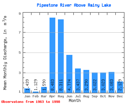
| Statistic | Jan | Feb | Mar | Apr | May | Jun | Jul | Aug | Sep | Oct | Nov | Dec | Annual |
|---|---|---|---|---|---|---|---|---|---|---|---|---|---|
| Mean | 1.44 | 1.13 | 1.59 | 8.48 | 8.31 | 4.77 | 3.44 | 3.29 | 3.02 | 3.02 | 3.08 | 2.13 | 3.46 |
| Standard Deviation | 0.86 | 0.54 | 0.90 | 4.77 | 4.71 | 3.73 | 2.33 | 3.15 | 3.67 | 3.51 | 2.74 | 1.16 | 1.37 |
| Min | 0.57 | 0.48 | 0.72 | 2.30 | 1.51 | 0.55 | 0.53 | 0.15 | 0.01 | 0.17 | 0.58 | 0.53 | 1.80 |
| Max | 4.04 | 2.87 | 3.87 | 18.60 | 19.10 | 14.90 | 9.09 | 8.64 | 11.50 | 13.40 | 12.70 | 4.12 | 7.04 |
| Coefficient of Variation | 0.60 | 0.47 | 0.57 | 0.56 | 0.57 | 0.78 | 0.68 | 0.96 | 1.21 | 1.16 | 0.89 | 0.54 | 0.40 |
 Return to R-Arctic Net Home Page