|
|
|||||||||||||||||
| Point ID: 4392 | Downloads | Plots | Site Data | Code: 05PB015 |
|
|
|||||||||||||||||
| Download | |
|---|---|
| Site Descriptor Information | Site Time Series Data |
| Link to all available data | |
| View: | Time Series | All |
| Units: | m3/s |
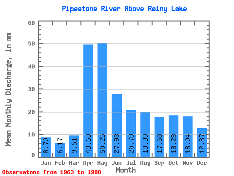
| Statistic | Jan | Feb | Mar | Apr | May | Jun | Jul | Aug | Sep | Oct | Nov | Dec | Annual |
|---|---|---|---|---|---|---|---|---|---|---|---|---|---|
| Mean | 8.70 | 6.22 | 9.61 | 49.63 | 50.24 | 27.93 | 20.78 | 19.89 | 17.68 | 18.27 | 18.04 | 12.87 | 246.63 |
| Standard Deviation | 5.19 | 2.95 | 5.46 | 27.92 | 28.44 | 21.81 | 14.09 | 19.02 | 21.45 | 21.24 | 16.04 | 6.98 | 97.36 |
| Min | 3.43 | 2.63 | 4.34 | 13.46 | 9.13 | 3.19 | 3.17 | 0.93 | 0.06 | 1.03 | 3.40 | 3.17 | 128.13 |
| Max | 24.42 | 15.81 | 23.39 | 108.83 | 115.46 | 87.18 | 54.95 | 52.23 | 67.29 | 81.00 | 74.31 | 24.91 | 501.48 |
| Coefficient of Variation | 0.60 | 0.47 | 0.57 | 0.56 | 0.57 | 0.78 | 0.68 | 0.96 | 1.21 | 1.16 | 0.89 | 0.54 | 0.40 |
 Return to R-Arctic Net Home Page