|
|
|||||||||||||||||
| Point ID: 4391 | Downloads | Plots | Site Data | Code: 05PB014 |
|
|
|||||||||||||||||
| Download | |
|---|---|
| Site Descriptor Information | Site Time Series Data |
| Link to all available data | |
| View: | Time Series | All |
| Units: | mm |
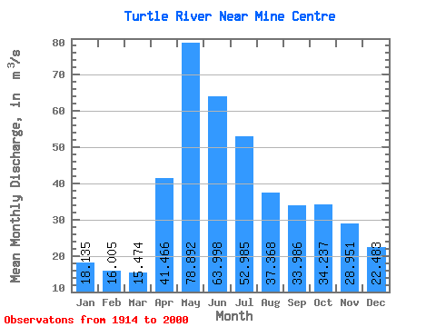
| Statistic | Jan | Feb | Mar | Apr | May | Jun | Jul | Aug | Sep | Oct | Nov | Dec | Annual |
|---|---|---|---|---|---|---|---|---|---|---|---|---|---|
| Mean | 18.14 | 16.00 | 15.47 | 41.47 | 78.89 | 64.00 | 52.98 | 37.37 | 33.99 | 34.24 | 28.95 | 22.48 | 37.38 |
| Standard Deviation | 9.23 | 7.16 | 6.18 | 18.11 | 43.37 | 33.51 | 29.05 | 19.86 | 25.50 | 31.63 | 21.99 | 13.68 | 13.83 |
| Min | 4.06 | 2.34 | 3.27 | 9.51 | 19.30 | 17.20 | 10.60 | 4.32 | 2.50 | 4.89 | 5.86 | 5.80 | 12.66 |
| Max | 51.50 | 37.60 | 33.10 | 86.00 | 204.00 | 166.00 | 189.00 | 89.90 | 175.00 | 236.00 | 140.00 | 78.70 | 75.27 |
| Coefficient of Variation | 0.51 | 0.45 | 0.40 | 0.44 | 0.55 | 0.52 | 0.55 | 0.53 | 0.75 | 0.92 | 0.76 | 0.61 | 0.37 |
 Return to R-Arctic Net Home Page