|
|
|||||||||||||||||
| Point ID: 4391 | Downloads | Plots | Site Data | Code: 05PB014 |
|
|
|||||||||||||||||
| Download | |
|---|---|
| Site Descriptor Information | Site Time Series Data |
| Link to all available data | |
| View: | Time Series | All |
| Units: | m3/s |
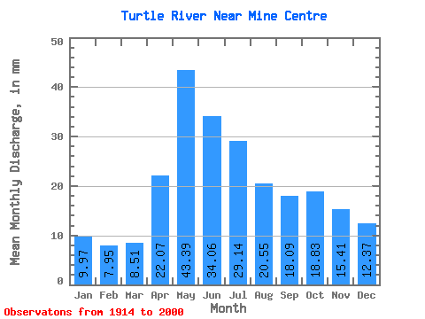
| Statistic | Jan | Feb | Mar | Apr | May | Jun | Jul | Aug | Sep | Oct | Nov | Dec | Annual |
|---|---|---|---|---|---|---|---|---|---|---|---|---|---|
| Mean | 9.97 | 8.02 | 8.51 | 22.07 | 43.38 | 34.06 | 29.14 | 20.55 | 18.09 | 18.83 | 15.41 | 12.36 | 242.22 |
| Standard Deviation | 5.08 | 3.59 | 3.40 | 9.64 | 23.85 | 17.84 | 15.98 | 10.92 | 13.57 | 17.39 | 11.71 | 7.52 | 89.60 |
| Min | 2.23 | 1.17 | 1.80 | 5.06 | 10.61 | 9.15 | 5.83 | 2.38 | 1.33 | 2.69 | 3.12 | 3.19 | 82.03 |
| Max | 28.32 | 18.84 | 18.20 | 45.77 | 112.18 | 88.35 | 103.93 | 49.44 | 93.14 | 129.78 | 74.51 | 43.28 | 487.76 |
| Coefficient of Variation | 0.51 | 0.45 | 0.40 | 0.44 | 0.55 | 0.52 | 0.55 | 0.53 | 0.75 | 0.92 | 0.76 | 0.61 | 0.37 |
 Return to R-Arctic Net Home Page