|
|
|||||||||||||||||
| Point ID: 4378 | Downloads | Plots | Site Data | Code: 04MD004 |
|
|
|||||||||||||||||
| Download | |
|---|---|
| Site Descriptor Information | Site Time Series Data |
| Link to all available data | |
| View: | Time Series | All |
| Units: | mm |
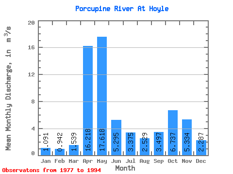
| Statistic | Jan | Feb | Mar | Apr | May | Jun | Jul | Aug | Sep | Oct | Nov | Dec | Annual |
|---|---|---|---|---|---|---|---|---|---|---|---|---|---|
| Mean | 1.09 | 0.94 | 1.54 | 16.22 | 17.62 | 5.29 | 3.38 | 2.53 | 3.50 | 6.74 | 5.33 | 2.29 | 5.56 |
| Standard Deviation | 0.22 | 0.34 | 1.14 | 6.20 | 9.07 | 3.32 | 2.30 | 1.93 | 1.84 | 3.08 | 2.63 | 0.74 | 0.97 |
| Min | 0.74 | 0.43 | 0.41 | 2.61 | 4.49 | 1.26 | 0.50 | 0.56 | 0.53 | 2.51 | 2.47 | 1.36 | 4.18 |
| Max | 1.47 | 1.83 | 5.10 | 25.90 | 35.90 | 11.70 | 7.25 | 7.62 | 7.00 | 13.30 | 13.90 | 4.07 | 7.57 |
| Coefficient of Variation | 0.20 | 0.36 | 0.74 | 0.38 | 0.52 | 0.63 | 0.68 | 0.76 | 0.53 | 0.46 | 0.49 | 0.32 | 0.17 |
 Return to R-Arctic Net Home Page