|
|
|||||||||||||||||
| Point ID: 4378 | Downloads | Plots | Site Data | Code: 04MD004 |
|
|
|||||||||||||||||
| Download | |
|---|---|
| Site Descriptor Information | Site Time Series Data |
| Link to all available data | |
| View: | Time Series | All |
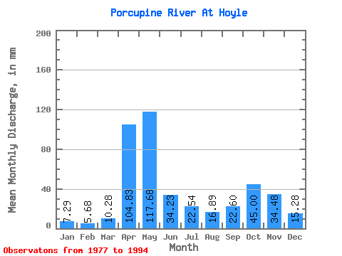
| Units: | m3/s |
| Statistic | Jan | Feb | Mar | Apr | May | Jun | Jul | Aug | Sep | Oct | Nov | Dec | Annual |
|---|---|---|---|---|---|---|---|---|---|---|---|---|---|
| Mean | 7.29 | 5.73 | 10.28 | 104.83 | 117.66 | 34.23 | 22.54 | 16.89 | 22.61 | 44.99 | 34.48 | 15.27 | 437.81 |
| Standard Deviation | 1.45 | 2.08 | 7.59 | 40.05 | 60.59 | 21.49 | 15.37 | 12.86 | 11.93 | 20.55 | 16.98 | 4.92 | 76.63 |
| Min | 4.92 | 2.63 | 2.74 | 16.87 | 29.99 | 8.14 | 3.33 | 3.72 | 3.39 | 16.76 | 15.97 | 9.08 | 329.38 |
| Max | 9.82 | 11.13 | 34.06 | 167.41 | 239.75 | 75.63 | 48.42 | 50.89 | 45.25 | 88.82 | 89.85 | 27.18 | 595.91 |
| Coefficient of Variation | 0.20 | 0.36 | 0.74 | 0.38 | 0.52 | 0.63 | 0.68 | 0.76 | 0.53 | 0.46 | 0.49 | 0.32 | 0.17 |
 Return to R-Arctic Net Home Page