|
|
|||||||||||||||||
| Point ID: 4375 | Downloads | Plots | Site Data | Code: 04MC002 |
|
|
|||||||||||||||||
| Download | |
|---|---|
| Site Descriptor Information | Site Time Series Data |
| Link to all available data | |
| View: | Time Series | All |
| Units: | mm |
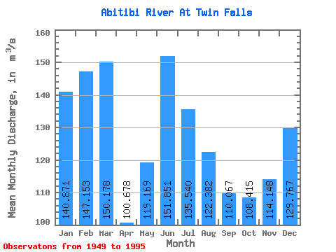
| Statistic | Jan | Feb | Mar | Apr | May | Jun | Jul | Aug | Sep | Oct | Nov | Dec | Annual |
|---|---|---|---|---|---|---|---|---|---|---|---|---|---|
| Mean | 140.87 | 147.15 | 150.18 | 100.68 | 119.17 | 151.85 | 135.54 | 122.38 | 110.07 | 108.42 | 114.15 | 129.77 | 127.58 |
| Standard Deviation | 30.34 | 38.56 | 35.44 | 29.79 | 90.17 | 83.73 | 46.17 | 23.25 | 19.00 | 38.20 | 40.86 | 32.21 | 22.04 |
| Min | 82.70 | 88.20 | 83.90 | 39.90 | 18.80 | 69.00 | 64.30 | 80.50 | 74.80 | 47.50 | 58.00 | 81.50 | 94.64 |
| Max | 221.00 | 312.00 | 281.00 | 167.00 | 443.00 | 452.00 | 299.00 | 170.00 | 153.00 | 229.00 | 251.00 | 203.00 | 203.00 |
| Coefficient of Variation | 0.21 | 0.26 | 0.24 | 0.30 | 0.76 | 0.55 | 0.34 | 0.19 | 0.17 | 0.35 | 0.36 | 0.25 | 0.17 |
 Return to R-Arctic Net Home Page