|
|
|||||||||||||||||
| Point ID: 4375 | Downloads | Plots | Site Data | Code: 04MC002 |
|
|
|||||||||||||||||
| Download | |
|---|---|
| Site Descriptor Information | Site Time Series Data |
| Link to all available data | |
| View: | Time Series | All |
| Units: | m3/s |
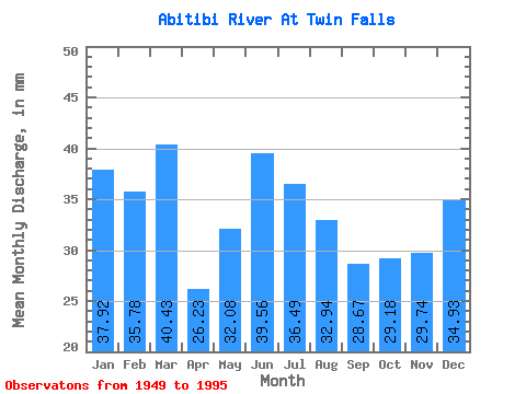
| Statistic | Jan | Feb | Mar | Apr | May | Jun | Jul | Aug | Sep | Oct | Nov | Dec | Annual |
|---|---|---|---|---|---|---|---|---|---|---|---|---|---|
| Mean | 37.91 | 36.09 | 40.42 | 26.23 | 32.07 | 39.56 | 36.48 | 32.94 | 28.67 | 29.18 | 29.74 | 34.93 | 404.68 |
| Standard Deviation | 8.17 | 9.46 | 9.54 | 7.76 | 24.27 | 21.81 | 12.43 | 6.26 | 4.95 | 10.28 | 10.64 | 8.67 | 69.91 |
| Min | 22.26 | 21.63 | 22.58 | 10.39 | 5.06 | 17.98 | 17.31 | 21.67 | 19.49 | 12.78 | 15.11 | 21.93 | 300.19 |
| Max | 59.48 | 76.51 | 75.63 | 43.50 | 119.23 | 117.75 | 80.47 | 45.76 | 39.86 | 61.63 | 65.39 | 54.64 | 643.89 |
| Coefficient of Variation | 0.21 | 0.26 | 0.24 | 0.30 | 0.76 | 0.55 | 0.34 | 0.19 | 0.17 | 0.35 | 0.36 | 0.25 | 0.17 |
 Return to R-Arctic Net Home Page