|
|
|||||||||||||||||
| Point ID: 4373 | Downloads | Plots | Site Data | Code: 04MB003 |
|
|
|||||||||||||||||
| Download | |
|---|---|
| Site Descriptor Information | Site Time Series Data |
| Link to all available data | |
| View: | Time Series | All |
| Units: | mm |
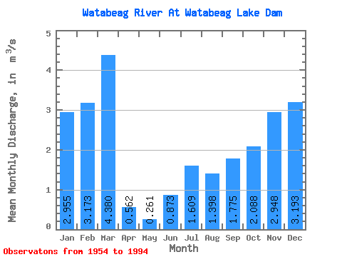
| Statistic | Jan | Feb | Mar | Apr | May | Jun | Jul | Aug | Sep | Oct | Nov | Dec | Annual |
|---|---|---|---|---|---|---|---|---|---|---|---|---|---|
| Mean | 2.96 | 3.17 | 4.38 | 0.56 | 0.26 | 0.87 | 1.61 | 1.40 | 1.77 | 2.09 | 2.95 | 3.19 | 2.15 |
| Standard Deviation | 3.09 | 2.28 | 3.44 | 0.98 | 0.66 | 1.61 | 2.09 | 1.89 | 2.54 | 2.05 | 2.36 | 2.93 | 0.88 |
| Min | 0.00 | 0.00 | 0.00 | 0.00 | 0.00 | 0.00 | 0.00 | 0.00 | 0.00 | 0.00 | 0.00 | 0.00 | 0.47 |
| Max | 10.10 | 7.35 | 11.10 | 3.78 | 2.75 | 7.31 | 9.18 | 8.22 | 11.30 | 7.88 | 9.13 | 11.70 | 3.84 |
| Coefficient of Variation | 1.04 | 0.72 | 0.78 | 1.74 | 2.53 | 1.85 | 1.30 | 1.35 | 1.43 | 0.98 | 0.80 | 0.92 | 0.41 |
 Return to R-Arctic Net Home Page