|
|
|||||||||||||||||
| Point ID: 4373 | Downloads | Plots | Site Data | Code: 04MB003 |
|
|
|||||||||||||||||
| Download | |
|---|---|
| Site Descriptor Information | Site Time Series Data |
| Link to all available data | |
| View: | Time Series | All |
| Units: | m3/s |
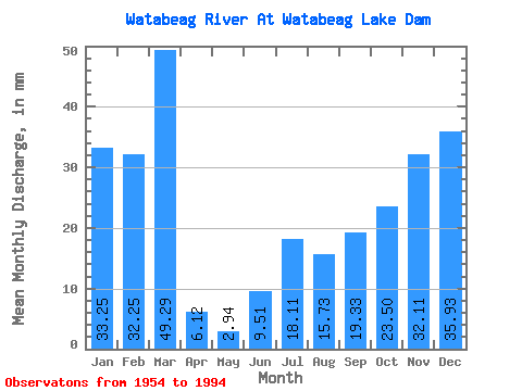
| Statistic | Jan | Feb | Mar | Apr | May | Jun | Jul | Aug | Sep | Oct | Nov | Dec | Annual |
|---|---|---|---|---|---|---|---|---|---|---|---|---|---|
| Mean | 33.25 | 32.53 | 49.29 | 6.12 | 2.94 | 9.51 | 18.11 | 15.72 | 19.33 | 23.49 | 32.11 | 35.92 | 285.74 |
| Standard Deviation | 34.76 | 23.41 | 38.66 | 10.65 | 7.44 | 17.57 | 23.56 | 21.22 | 27.70 | 23.03 | 25.68 | 32.94 | 115.99 |
| Min | 0.00 | 0.00 | 0.00 | 0.00 | 0.00 | 0.00 | 0.00 | 0.00 | 0.00 | 0.00 | 0.00 | 0.00 | 63.02 |
| Max | 113.65 | 75.35 | 124.90 | 41.17 | 30.94 | 79.61 | 103.29 | 92.49 | 123.07 | 88.67 | 99.43 | 131.65 | 508.78 |
| Coefficient of Variation | 1.04 | 0.72 | 0.78 | 1.74 | 2.53 | 1.85 | 1.30 | 1.35 | 1.43 | 0.98 | 0.80 | 0.92 | 0.41 |
 Return to R-Arctic Net Home Page