|
|
|||||||||||||||||
| Point ID: 4318 | Downloads | Plots | Site Data | Code: 04CA002 |
|
|
|||||||||||||||||
| Download | |
|---|---|
| Site Descriptor Information | Site Time Series Data |
| Link to all available data | |
| View: | Time Series | All |
| Units: | mm |
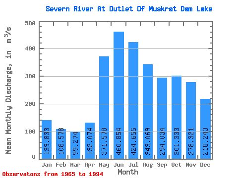
| Statistic | Jan | Feb | Mar | Apr | May | Jun | Jul | Aug | Sep | Oct | Nov | Dec | Annual |
|---|---|---|---|---|---|---|---|---|---|---|---|---|---|
| Mean | 139.83 | 108.58 | 99.27 | 132.07 | 371.58 | 460.85 | 424.65 | 343.07 | 294.03 | 301.33 | 278.32 | 218.24 | 259.80 |
| Standard Deviation | 52.07 | 30.87 | 27.61 | 48.69 | 150.45 | 189.69 | 189.32 | 147.85 | 152.91 | 188.34 | 169.56 | 135.66 | 92.62 |
| Min | 43.20 | 35.70 | 35.60 | 63.50 | 96.60 | 93.90 | 168.00 | 128.00 | 107.00 | 102.00 | 87.30 | 63.80 | 124.07 |
| Max | 275.00 | 163.00 | 142.00 | 250.00 | 625.00 | 846.00 | 881.00 | 617.00 | 702.00 | 1100.00 | 982.00 | 753.00 | 512.17 |
| Coefficient of Variation | 0.37 | 0.28 | 0.28 | 0.37 | 0.41 | 0.41 | 0.45 | 0.43 | 0.52 | 0.62 | 0.61 | 0.62 | 0.36 |
 Return to R-Arctic Net Home Page