|
|
|||||||||||||||||
| Point ID: 4318 | Downloads | Plots | Site Data | Code: 04CA002 |
|
|
|||||||||||||||||
| Download | |
|---|---|
| Site Descriptor Information | Site Time Series Data |
| Link to all available data | |
| View: | Time Series | All |
| Units: | m3/s |
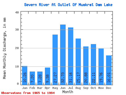
| Statistic | Jan | Feb | Mar | Apr | May | Jun | Jul | Aug | Sep | Oct | Nov | Dec | Annual |
|---|---|---|---|---|---|---|---|---|---|---|---|---|---|
| Mean | 10.26 | 7.26 | 7.28 | 9.38 | 27.26 | 32.73 | 31.16 | 25.17 | 20.88 | 22.11 | 19.77 | 16.01 | 224.64 |
| Standard Deviation | 3.82 | 2.06 | 2.03 | 3.46 | 11.04 | 13.47 | 13.89 | 10.85 | 10.86 | 13.82 | 12.04 | 9.95 | 80.09 |
| Min | 3.17 | 2.39 | 2.61 | 4.51 | 7.09 | 6.67 | 12.33 | 9.39 | 7.60 | 7.48 | 6.20 | 4.68 | 107.28 |
| Max | 20.18 | 10.90 | 10.42 | 17.75 | 45.86 | 60.08 | 64.64 | 45.27 | 49.85 | 80.71 | 69.73 | 55.25 | 442.85 |
| Coefficient of Variation | 0.37 | 0.28 | 0.28 | 0.37 | 0.41 | 0.41 | 0.45 | 0.43 | 0.52 | 0.62 | 0.61 | 0.62 | 0.36 |
 Return to R-Arctic Net Home Page